

There are places where history is not found in museums — it is found in the air, in the water, in the stone walls that still stand. The area of Myloni in Mylopotamos, Kythera, is one of them. Here, in a valley that is shady and cool even in August, 22 watermills once operated in full production. Today, five survive in remarkable condition, enough to give you a sense of what this place meant to the life of the island.
I have walked this path dozens of times, at different times of the day and seasons. In April, when the water is running strong and the sound follows you the entire way. In August, when the waterfall has risen but the coolness of the valley remains. In November, when the place is empty of visitors and you feel like you have it all to yourself. Every time I find something I hadn’t noticed before: a detail in the stonework, an irrigation canal that still carries water, an inscription carved into a rock that tells a name and a date.
Mylopotamos got its name from there — river of mills. It’s not a poetic name. It is a description of a place that built its entire life around running water.
THE HISTORY OF THE WATERMILLS
The watermills of Mylopotamos date back to the Venetian era — probably the 16th century, when the Venetians systematically organized the island’s agricultural production. Their heyday is placed in the 18th and 19th centuries: at that time, the milling of wheat, barley and corn was the industry of the time for the entire wider region.
Their supply came from the springs of Kamari — a rare and invaluable commodity on an island in the southern Aegean. The water was led through irrigation canals to the wheels of each mill, and the strength of the current determined how many mills it could supply at the same time. At their peak, 22 mills operated in a staggered arrangement along the valley — a rare example of industrial organization for the time.
Life around the mills
Each mill was an autonomous micro-economy. It had its own miller, assistants, storage space, and often animals that transported the grain from the villages inland. Farmers from all over the island brought wheat here — they paid with part of the flour as a reward, they got the rest back. A simple, undisputed, centuries-old economic cycle.
Near the mills there were also auxiliary facilities: warehouses, stables, wells. Some mills also had small rooms for farmers who came from far away and stayed all night waiting for the grinding. The place was not just industrial — it was social.
WHAT IS SAVED TODAY
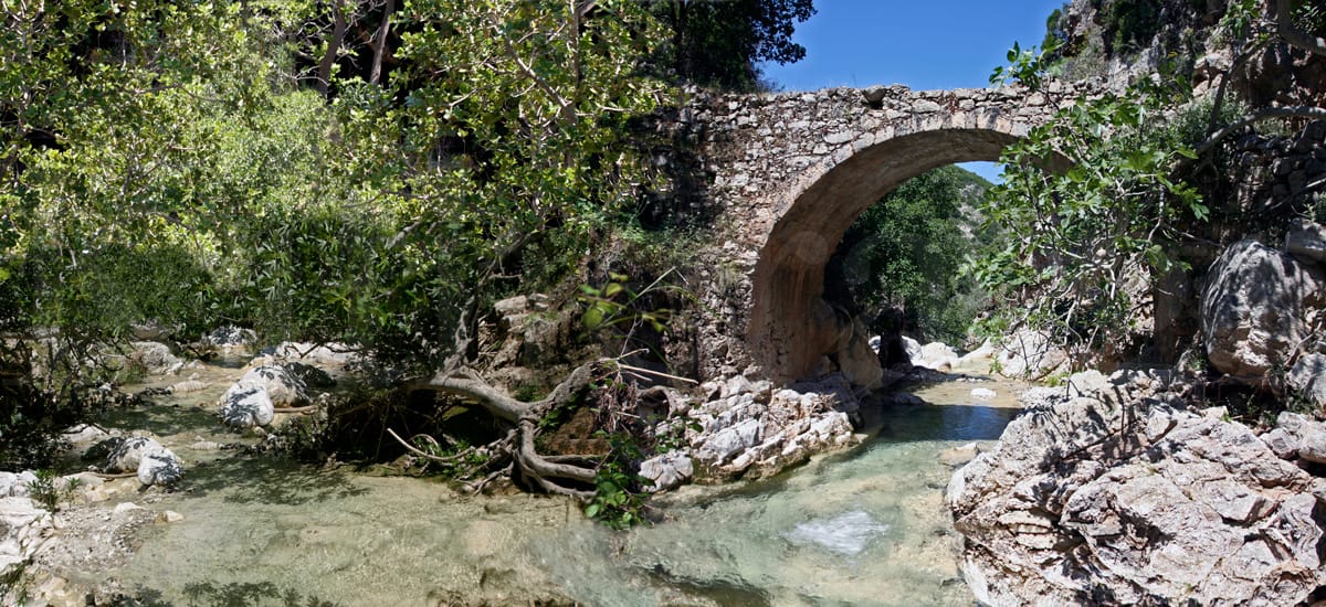
The mills ceased to operate in the 1960s–70s, when flour mills with internal combustion engines made water mills economically unprofitable. Of the 22, five survive in relatively good condition with the stone walls, arches and parts of the mechanism visible.
The most famous, the Water Mill of Philippi, had been carefully restored and operated as a museum. After the loss of its owner, it remains closed. It is a loss that is felt — but even closed, the mill does not lose its power.
First-hand: Even without going inside any of the mills, the walk along the valley is unforgettable in itself. The stone bridges, the irrigation canals, the centuries-old plane trees — all together form a setting that you don’t easily find elsewhere in Greece.
WHY THEY ARE UNIQUE IN GREECE
Watermills exist in many parts of Greece. What makes the Mylopotamos Mills unique is the combination of three elements: the density (22 mills in such a small area), the state of preservation, and the natural beauty of the area. This combination — industrial history amidst a natural landscape of rare beauty — is what makes the place resist oblivion.
THE ROUTE
Accessis from the central settlement of Agios Sostis, following the sign “Mills — Neraida”. The path is paved and downhill, about 15–20 minutes at a comfortable pace. As you descend, the character of the place gradually changes: the trees thicken, the temperature drops, the sound of the water begins to be heard before you see it.
At the end of the route you first encounter the Neraida Waterfall. From there, following the path, you reach the central area of the watermills. The ideal route is circular: go down to Neraida, walk along the mills, and return by a different road through the settlement.
Practical information:
Start: Agios Sostis, Mylopotamos — sign to “Mills–Neraida”, I recommend you go down the path which is wonderful, and not from the parking lot.
Distance from Chora: ~15 km. (20 minutes by car)
Walking time: 45–75 minutes (Mills + Fonissas waterfall)
Difficulty: Easy — downhill cobblestone, suitable for everyone
Best season: Spring and autumn
Best time: Morning before 10:00
Shoes: Athletic or hiking
Suitable for: All ages, families with children
Combined with: Kato Chora Castle, Agia Sophia Cave, which unfortunately will remain closed for this year.
WHEN IS IT BEST — SEASONS
Spring (March–May): the peak
The best season. The water is at its highest flow, the waterfall is impressive, the vegetation is intensely green. Ideal for photography, hiking, visiting with children.
Summer (June–August): cool in the heat
Less water, but the ravine keeps the temperature 5–8 degrees lower than the rest of the island. Visit early in the morning
Autumn (September–November): quiet and light
The water starts to rise again. The place is almost empty. The autumn light — oblique, golden — ideal for photography.
Detailed guide to Mylopotamos: mylopotamo.gr
Information about all Kythira with authentic texts, photos, maps is provided by the complete, specialized and reliable travel guide to Kythira: kithera.gr


